
Assistant Professor Rajesh Veeraraghavan leads mapping exercise to assist the Government of India in its response to the COVID-19 crisis
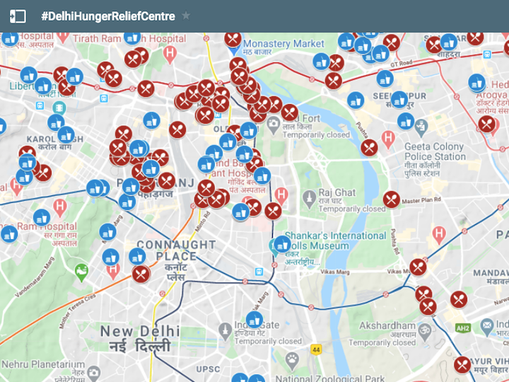
Rajesh Veeraraghavan, an assistant professor in the Science, Technology and International Affairs program in the School of Foreign Service and member of the India Initiative Faculty Advisory Committee, worked with researcher Hridbijoy Chakraborty to use the Urban Spatial Observatory’s (USO) dataset on public services with a focus on access in informal settlements as the framework for their first COVID-19 map, published on Twitter as #DelhiHungerReliefCentre.
On 24th March at 2000 hours IST, Indian Prime Minister Narendra Modi announced a countrywide lockdown to control the Coronavirus epidemic. As India’s already significant homeless and food insecure population has exploded over the past week, the government has faced one of its most difficult and important challenges to date. As central and state governments have sought to provide free food and humanitarian support, they have faced a number of challenges, including:
- Unavailability of settlement level data in cities, where population density particularly in informal settlements is very high.
- Unavailability of public infrastructure repository and shared access to information for different departments and researchers.
Immediately after the announcement of the India-wide lockdown, we started to work on releasing data and maps for the public good. Building upon our large dataset on public services with a focus on informal settlements we published our first map with #DelhiHungerReliefCentre on Twitter.
This article was originally published by Main Campus Research. Please follow the link to read the full story.